This small, but powerful, piece of equipment has revolutionized inshore fishing. Learn how in this Standard Mapping E-Card Review.
Standard Mapping E-Card Review
When I was a kid my dad did all of the navigating and driving.
Aside from the marsh closest to the marina, I couldn't tell you where I was exactly or how to get back. That changed as I got older.
Then it changed a lot after I joined the Marines, mastering navigation on the water and on land. After all, it was a basic skill in Amphibious Reconnaissance.
Those things I learned I brought home with me to inshore fishing.
Since the prairie marsh is so flat it is easy to get lost, but also easy to see landmarks from a distance, to include water towers and even well-known buildings in New Orleans. With these I could shoot re-sections across bayous to figure my position.
This gave me confidence to boldly go into unexplored territory.
Using Google Earth
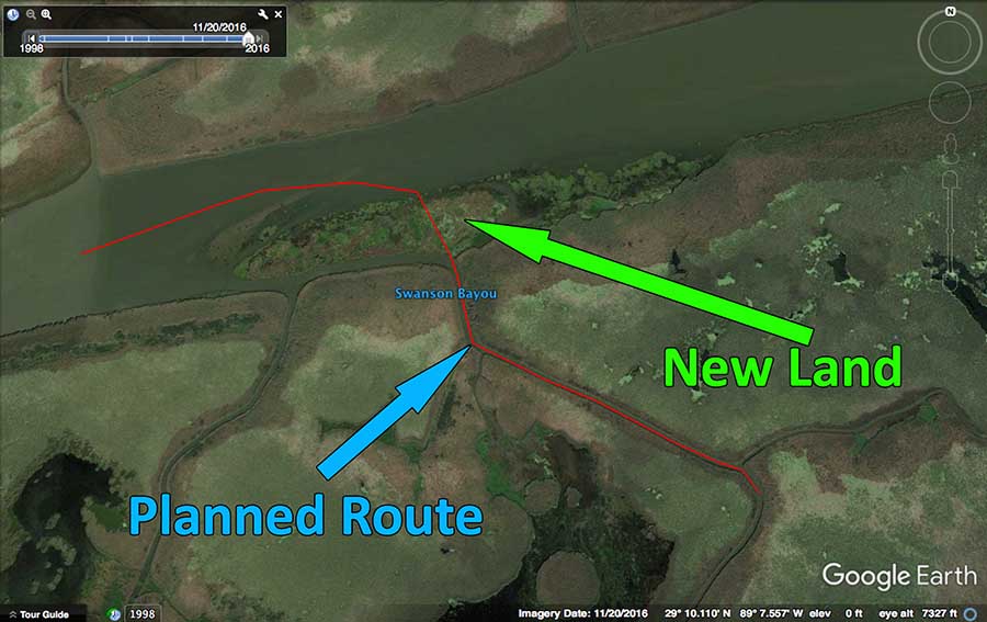
I kicked it up a notch with Keyhole Markup Language in Google Earth, learning how to create my own routes and upload them to my Garmin 60Cx, an inexpensive hand-held unit. I was always able to get around with this despite the stock maps being complete garbage.
I used different GPS units throughout the years, mostly Lowrance. Again, the stock maps were lacking.
I would have to program my own waypoints and routes to locate my fishing spots and get there. This was time consuming and left me "blind" in the marsh: I only knew what points I had programmed.
If there was a great, but unplanned, fishing spot a few miles away I wouldn't know how to get there.
As you can imagine, there are few cartographers with the patience, paper and No. 2 pencils to draw every nook and cranny of the Louisiana marsh.
Satellite imagery proves over and over again to be the top winner when it comes to navigating and finding great fishing spots.
But I never used satellite imagery on my GPS units in my boat. I was really missing out and not taking full advantage of the Standard Mapping E-Card.
That all changed with the Standard Mapping E-Card
It was August of 2016 I attained a Standard Mapping E-Card, specifically their LA-1 or Louisiana One card.
This is an SD card, from the inshore mapping authority in Louisiana, designed to cover the entire Louisiana coast.
Since then I have fished marsh from Venice to Lake Charles with it.
This card is designed to work with popular GPS brands, like Lowrance and Simrad. I use mine in a Simrad Go5 XSE.
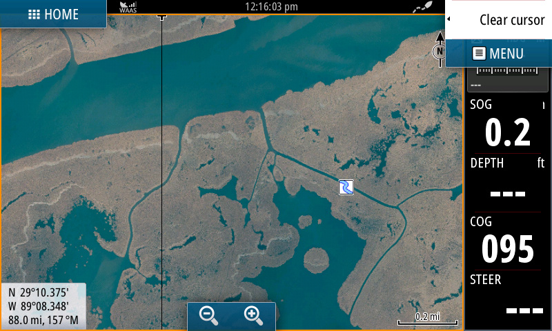
As you can see, the resolution is sharp and easy to discern all the bodies of water you would ever want to identify in the marsh.
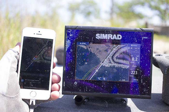
But can't I use my smart phone instead of a Standard Mapping E-Card?
Not really. Popular mapping apps like Google Earth are great for seeing satellite imagery but aren't fitted for on-the-go navigation in the marsh for the following reasons:
- there is little to no cell signal in the marsh, your maps won't load
- your phone will eat its battery up trying to communicate with distant towers and will eventually die
- Google Earth imagery has poor contrast and is difficult to differentiate between land and water
- most smartphone screens are not sunlight readable

I intentionally left the screen dirty as this is how it usually is during a fishing trip. Water gets on everything in my boat from flopping fish or sea spray. Despite this, the screen is still readable and usable.
But with Standard Mapping's LA-1 card, you can see the difference very easily. They are mapping experts who have taken the time to contrast the coloration between land and water.
The LA-1 card allows you to navigate foreign waters like a local.
You Still Have to Navigate With Common Sense
This chip does not make one a seasoned pro with a single purchase, rather experience still takes the lead and planning is still important for new areas.
While not necessary, creating your own custom GPS routes still makes for convenient navigating and organizing which spots you want to fish. However, I will tell you that the majority of my fishing trips I do not use custom routes.
I really only use custom routes if I am in a completely new area.
Some Terrain Changes over Time
It's not a secret the Louisiana coast is changing. It's not all land loss, either.
In some places land is building up! This is due to coastal restoration efforts but also to the land-building power of the Mighty Mississippi River.
One day, while exploring Venice for the Louisiana Saltwater Series Championship, I was headed up a bayou north into Pass A Loutre.
As I got closer to what I thought was the river I became perplexed. I didn't see navigable water, but land!
I came off plane and scratched my head before taking another gander at my Standard Mapping E-Card.

It was then I noticed I could go left, even though I could not see where it led me.
So I took that route. I had to go to know!
Turns out the channel was navigable and I was able to get into the river to continue my plan.

The Standard Mapping E-Card satellite imagery doesn't account for the land that the river built since the map was created. Fortunately, Standard Mapping updates their new products.
Now, it's important to note that Standard Mapping updates their chips with new satellite imagery and even the older stuff is still good to go for the majority of the Louisiana marsh.
The River Delta is just an easy example of terrain that is always changing.
My point is just because you have a little SD card in your possession does not mean you are exempt from navigational hazards.
If this were the case, I wouldn't have had this nasty accident where I lost my lower unit in Venice.
Seeing Standard Mapping E-Card is Believing
Here is a great video from Jonathan Howard that really demonstrates the difference between the Lowrance base map and the detail of a Standard Mapping E-Card.
Here is a video from Standard Mapping introducing the E-Card.
And there are directions for installing the Standard Mapping E-Card.
This is the best inshore navigation solution I have ever used.
It's accuracy and detail enables me to be a phenomenally better angler because I can flawlessly navigate wherever I want, whenever I want.
If there is a shortcut or good-looking pond around the corner I will know because of this card.
You can order your Standard Mapping E-Card from Standard Mapping’s website or call them at 985-898-0025. Be sure to tell them the Louisiana Fishing Blog sent you!
P.S.
Did you find what you learned here to be useful? Consider joining my newsletter to be notified when more like it publishes.

Are you asking how recent the imagery in the Standard Mapping card is?
How recent is the Arial view of the southeast LA is it
Yes, I’ve seen them work in that model before. Thanks for commenting!
Will it work with a NSS evo2 Simrad?
Yes, Standard Mapping now makes cards for Garmin units.
Thanks for commenting!
Is this compatible with Garmin gps?