MODIS satellite imagery is a great tool for Louisiana's inshore anglers, especially when it comes to finding clear water and staying away from non-productive dirty water.
But what is this new-fangled wizardry?
In this guide you'll learn what MODIS satellite imagery is, where to find it and how to use it for your inshore fishing trips. I've been using it for years and have found it to be a great indicator of where to find clear water for catching speckled trout and redfish, and hopefully you do, too!
What is MODIS satellite imagery?
It's a system of two NASA satellites that orbit Earth every day, taking pictures of its surface and making them available for viewing on the Internet.
The two satellites are named Terra and Aqua, and are timed to take a morning and afternoon picture of Louisiana.
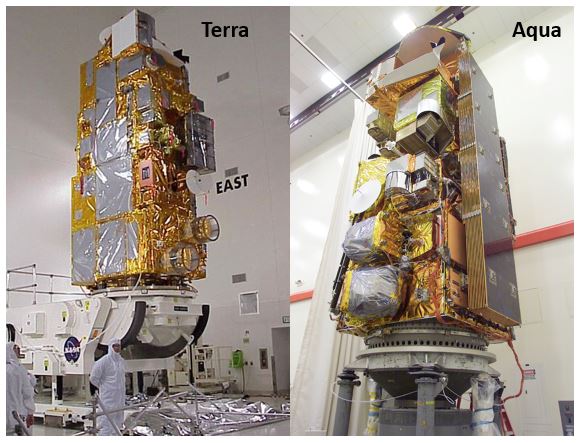
Aqua & Terra Won't Last Forever
According to this 2022 article on NASA's website, both satellites of the MODIS system have already lived beyond their intended lifespan. Simply put, they're living on borrowed time.
Once they're gone they will be replaced by something else and — by the time that has happened — I would have already figured out an alternative.
So be sure to subscribe so you don't miss that update or any future updates, especially if you love inshore fishing!
Just in case you're curious, "MODIS" stands for Moderate Resolution Imaging Spectroradiometer. I know, it sounds techy and sciencey, so how does this work for us inshore anglers?
How MODIS serves Louisiana's inshore anglers:
This NASA product solves a recurring problem in inshore fishing: it helps us discern where productive and unproductive fishing areas are.
It's generally accepted amongst fishermen that the best places to catch speckled trout and redfish are places where the water is clear, or clean.
The best fishing for specks and reds is generally not found in the midst of very dirty water. While they can certainly be had in less-than-perfect water clarity or even stained water, it's widely known that you want to find something that's appealingly clear.
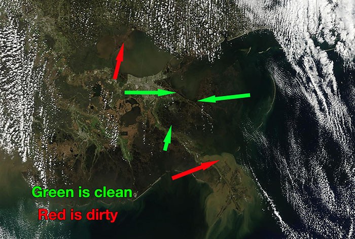
Probably the best way to show the value of MODIS satellite imagery is to demonstrate how it could save you a lot of gas and precious fishing time.
So we'll use this example during the summer:
Breton Island Summer Speckled Trout Example
Breton Island can be a really good fishing spot during the summer speckled trout pattern, and however it is you decide to get there — whether you launch from Hopedale, Venice or somewhere between — you are looking at a long boat ride.
It sure would be awful if you got up early, made the before-sunrise run across Breton Sound just to see that the island is covered in river water.
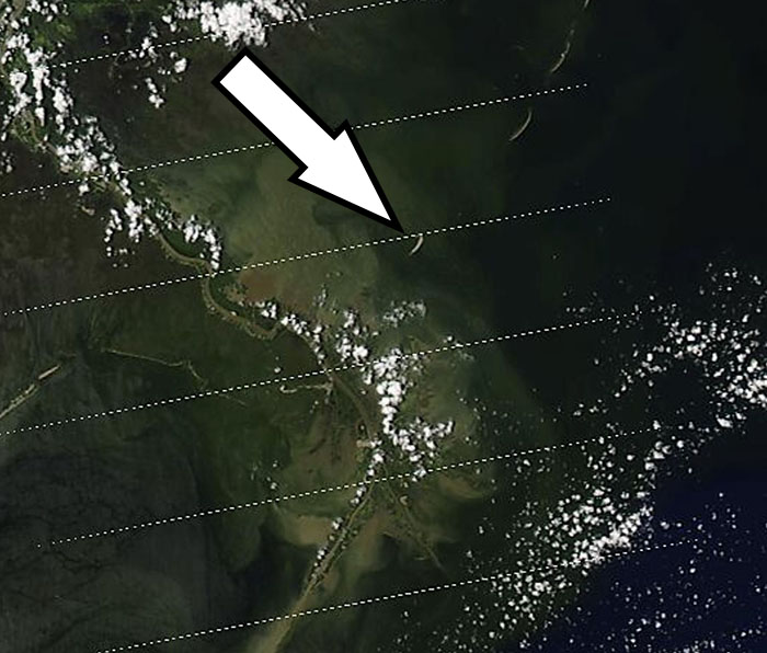
Breton Island appears to be clear of river water from the Mississippi River.
This is a likely scenario, since Breton Island is well within the influence of the Mighty Mississippi, especially when she's running in double digits at the Carrollton Gauge.
If the sky is clear the day before, MODIS satellite imagery can reveal if the island is clear or not. If it is, then you know it's worth trying. If it's not, then you know to try somewhere else.
Sight Fishing Redfish Example
Another great example of the power of MODIS would be planning a sight fishing trip for redfish. To do this you really need clear water so you can see the redfish swimming and make a good cast to it.
Well, this is where MODIS comes into play once again!
You can use it to see where the clearest water is on Louisiana's coast. It gives you a great starting point as where to launch your boat and begin looking.
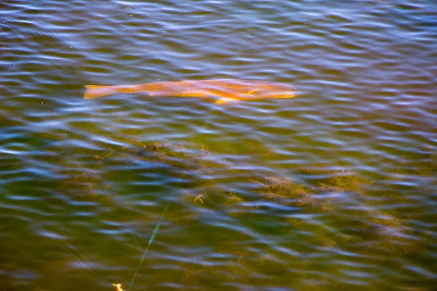
Sight fishing redfish is a lot of fun, and something you need to try!
How Do You Use MODIS Satellite Imagery?
So now you can appreciate the usefulness of the Terra and Aqua satellites and the great imagery they provide every day.
But how do you actually use them?
Well, you can get started by visiting this website (opens in new tab) hosted by the University of Wisconsin.
A Note About That Particular Website
That is the actual website I use when planning my own fishing trips.
While MODIS is available on a lot of different websites, I have found that one to be the most reliable and consistent in displaying MODIS imagery.
Once there, you'll see a composite of the United States, something like what you see below. You'll notice that there are a lot of options. We'll go over the ones you need to know about.
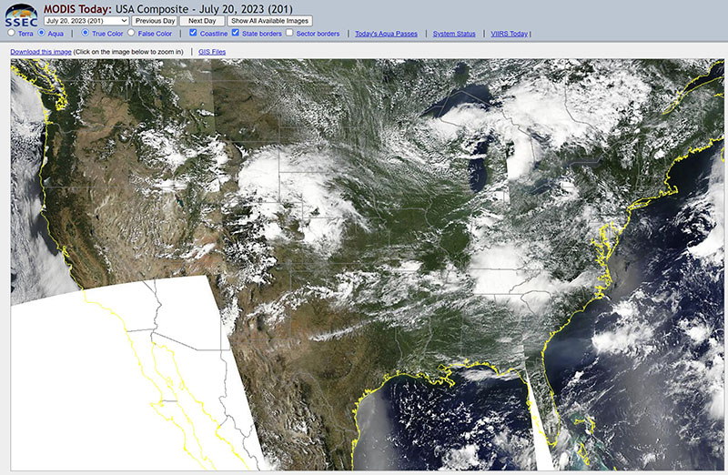
Note the two radio buttons in the upper left hand corner that say "Terra" and "Aqua". Whichever one is highlighted is the one that you are currently viewing. You can click on the other one in order to see that imagery.
Sometimes there will be clouds or sun sheen obscuring the view of the area you want to look at, so trying the other satellite can be a good choice for a clear image.
Next, you'll see that the composite image of the good ol' USA is actually made up of eight sectors, dubbed USA1 through USA8. Louisiana is USA7.
Now, I'm assuming you are fishing Louisiana (after all, the name of the website you're looking at it is Louisiana Fishing Blog — the name kinda gives it away — but you'll find confused people in the comments from time to time) so click on Louisiana.
But if you're in some place like South Carolina or Florida, then view that imagery instead. You can certainly put to work the knowledge that works for us in Louisiana wherever it is you are inshore fishing!
Once you click through you will be taken to the imagery for that sector.
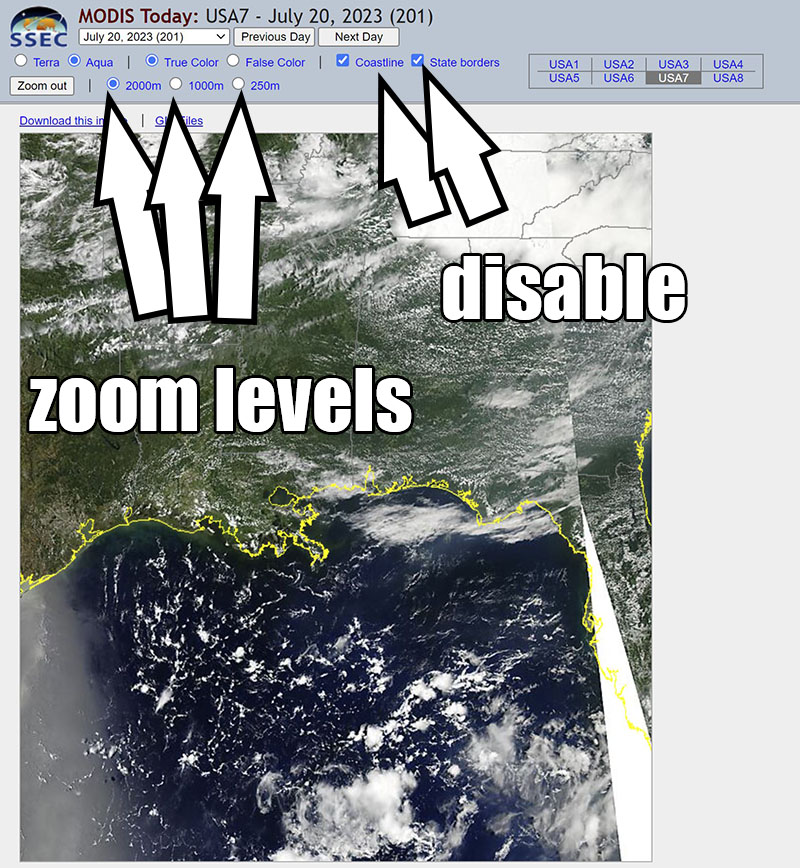
Now is when you want to play with the options above the image! You'll want to turn off the option for "coastline" and "state borders" so you can more clearly see the image.
Next, you'll see three radio buttons on the left denoting the image resolution:
- 2000m
- 1000m
- 250m
Note that the "m" stands for "meters per pixel".
So, 2000m is a wider view and 250m is a zoomed-in view.
Quick Note About This Resolution
The resolution of MODIS satellite imagery, even in its highest form, is still only that of about a football field per pixel.
This is not the same higher-resolution imagery you find in something like a mapping chip or Google Earth Desktop.
Which is fine, because that's not what you're using it for. You're using MODIS strictly to ascertain dirty/clear water for a given area.
So keep that in mind!
Go ahead and click on the 250m radio button, where you will be taken to an even larger image of the one you were just looking at.
This is the one you want to peruse! You have been warned: it is big. It's about 5,200 x 6,000 pixels and roughly 5 to 6MB in size.
Now that you have it up, go ahead and scroll to the area you want to view.
Oh, and another note: this is all so much easier to do on a desktop. If you don't use a desktop, you really ought to have one for inshore fishing, especially seeing that it can unlock the power of Google Earth Desktop. Anyway, moving on:
What you're looking for here is anywhere the water appears to be dark. The darker it is, the clearer it is. Anywhere it's tan or brown, well, that's dirty water.
Some Additional Notes About MODIS You Ought To Know
This satellite imagery is not perfect! It is only a tool in the toolbox, but your toolbox is better off having it than not.
And, while writing this guide, I thought of some additional points that I'd like to include here so you can get the most out of this tool:
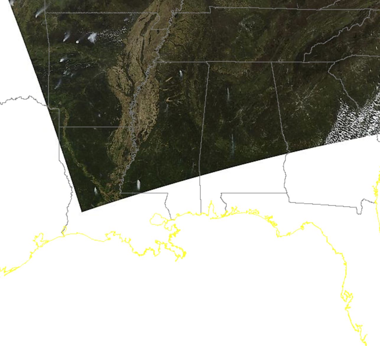
Sometimes MODIS Breaks Unexpectedly
It is what it is. Sometimes you get garbage images full of digital noise, or a satellite just goes offline. Who knows what's going on up there in space?
You're Still Subject To Nature: Clouds Happen
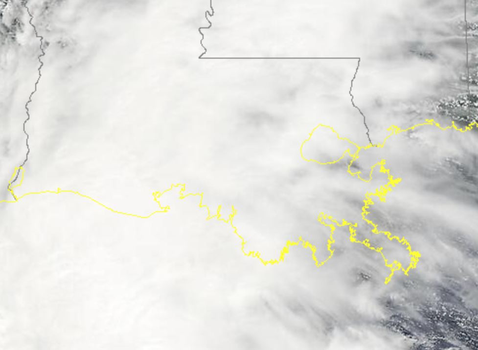
Sometimes the sky fills with clouds that make it impossible to see what's happening on Louisiana's surface. Oh well.
The best thing you can do is look at the most recent image available.
Where To Get More Inshore Fishing Tools, Knowledge & Support
Hopefully you found this guide helpful and use what's here to fuel your next fishing trip! But you should know that there are more tools you can learn about in my course, Fishing Trip Resources & How To Use Them, as well as a process to finding and catching speckled trout and redfish.
That process is what I teach inside my course Inshore Fishing 101, as well as how to use various tools (like MODIS satellite imagery) to decide where to go and what to fish for.
Inshore Fishing 101 is only available inside my membership, LAFB Elite. When you join, you gain access to all of my courses as well as the LAFB Elite Community, where you can discuss your next fishing trip with like-minded anglers.
I fished largemouth bass in Arizona’s Salt River reservoirs (Saguaro, Canyon, and Apache Lakes) for years, and then moved back to Louisiana after decades of being away.
I wondered if all that bass knowledge and skill would be useful here in saltwater. Devin has showed me how incredibly useful it is! I don’t regret for one microsecond the money I spend on his membership, LAFB Elite.
Chuck Roger
I really appreciate Devin's teaching & how he is "to the point" and down to earth, yet professional and gives a great presentation of what I need to know in order to catch speckled trout and redfish.
Before taking Inshore Fishing 101 I have not had very many successful trips to Louisiana, but with these great learning experiences, since completing 101, I have had more success. Finding the best conditions, using the right tackle, Google Earth Desktop & technical stuff on my Lowrance, etc., the list is too long for this, so THANKS from a rookie inshore fisherman!!!
Captain Devin has done an excellent job with these classes! As a speaker, preacher, college teacher, & singer I appreciate the research, experience, time, & knowledge he put into the great presentations of each class. I can not suggest any changes for such an excellent course!
Ira Burge
I grew up fishing Delacroix with my dad from age 8-14. I never understood what we were doing or why, and didn’t think to ask questions. Dad did all the leg work and put us on the fish, I just threw at 'em and reeled 'em in.
Today, Captain Devin's Inshore Fishing 101 helped me learn all the things my dad knew to make those fishing trips happen. I'm able to plan good fishing trips to find 'em and catch 'em.
This is much easier due to Devin's ability to "dumb things down" and make fishing concepts easily understandable.
Now 18 years later we are getting a new boat and getting back on the water. Looking forward to showing Dad what I have learned!

Hey Jim, thanks for commenting.
I get this a lot about Vermillion Bay and can tell you that you’re not alone.
The short answer is: yes I do.
The long answer:
I don’t feel Vermillion Bay is any different from Delacroix, Venice, Slidell or Dularge.
Why is the fishing hard in Vermillion Bay?
Because it’s covered in river water most of the year.
Try as you might, a round peg will never fit into a square hole.
Think about it, how many guides do you know of that fish Vermillion Bay full time?
I haven’t heard of any.
With this in mind, Vermillion Bay is not the only place in Louisiana that gets river water.
Slidell, Delacroix, Venice, Dularge, Pointe a La Hache and more all get just as much of that nasty, brown river water.
When that brown water rolls in, fishing comes to a screaming halt.
When it does, we go somewhere else.
Nobody catching fish does so by staying put and casting into that dirty, sediment-laden, nasty river water.
But, when the river water eventually recedes, becomes clear and a tad saltier, the fishing is on fire.
And I think that’s what happens with Vermillion Bay.
The Atchafalaya eventually goes down, south winds blow and the fishing turns on.
Folks hear about the great fishing, can’t wait to go, and eventually launch the boat during opposite conditions, get their ass kicked and go home thinking the people who did catch must have a crystal ball or something.
So, as it pertains to this website, there are tons of information to help you.
Things like locating clean water, and understanding seasonal movements of fish according to the bigger picture (and the Atchafalaya is part of that).
It’s going to take hard work on your part, too.
I don’t think anyone can expect to be receive a “silver bullet” that immediately enables them to catch limits of fish on every trip.
But, if you’re willing to put in the time to fish hard, then searching this website isn’t very hard in comparison.
To make it easier, I created this article breaking down the best way to do that: https://www.lafishblog.com/search-louisiana-fishing-blog/
Thanks, Jim.
I notice all your fishing tips and advice are centered around SE La. I live in Lafayette. I fish primarily in Vermilion Bay. I believe this is the most difficult area to fish out of the SW area, the Central area (Vermilion Bay area), and the SE Area. I believe it is due to the sediment coming out of the Vermilion River and the Calumet Cut. You can easily see this on MODIS. My question is: Do you ever have any tips or advice in the Central Area.
Jim
Pretty neat, huh?
Thanks for commenting!
Nice technology, I’m really glad you took the time to share this. I had no idea this existed!