Louisiana's coast is not a static thing, nor does it exist in a vacuum. It is always changing, and some of those most prolific changes are a direct result of something else happening on the continent.
If I could identify and name one such change, it would be The Freshening.
And it's very important that I do so because people have a notoriously short memory! This is an opportunity to identify this important event in Louisiana's history, while we are still close to it in time. That and it'd be great to have this resource to point to and say "remember that?"
So, I begin with explaining exactly what it is:
What is "The Freshening"?
The Freshening is a period from 2011 to 2020 where Louisiana saw historically high amounts of river water delivered to her coast.
During this period we saw multiple openings of the Bonnet Carre Spillway, consistently high river levels during times they should have been low or dropping and, most shocking of all, a never before seen back-to-back spillway opening in a single year.
The kingpin of this event was the Mississippi River, but other rivers bear responsibility, too.
In 2016 we saw 500 and 1,000-year floods of the Pearl and Amite Rivers, both of which empty into the Lake Pontchartrain Basin. Even further down the coast in places like Alabama, the Mobile River was much higher, leading to more widespread river water.
Out west it was the same story at the Sabine, with Toledo Bend hitting a record lake level of 174.4 feet in March 2016, leading to the largest release of water from its spillway gates.
Of course, because it is connected to the Mighty Mississippi, the Atchafalaya River was also historically high, drastically influencing the Vermillion Bay complex by inundating it with record amounts of dirty river water.
In short, Louisiana's salty coast saw a lot of river water, way more than normal. So much that places that were traditionally salty became pretty fresh.
This affected the inshore species of fish that live here, as well as changed the landscape.
Let's go over both those points, beginning with river water's affect on inshore species:
How did The Freshening Affect Inshore Species?
River water is an important element to a thriving inshore fishery. Without it we are in the hurt locker, and that's because river water helps build the food chain from the bottom up.
Dirty river water delivers valuable nutrients to the sea, giving food for plankton and aquatic grasses to grow, which in turn feeds oysters and menhaden (that we call "pogeys" here in Louisiana), which in turn feed the rest of the food chain.
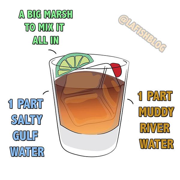
Think of Louisiana's coast as being like a carefully mixed cocktail. Too much of one ingredient can cause an imbalance, and a less-tasty drink that's not so enjoyable.
But too much river water can reduce or outweigh those benefits. All the extra river water (and believe me, we got a lot of it) had dire impacts on Louisiana's coast.
Let's start with the bad stuff:
Oyster Reefs Killed Off
Places like the Biloxi Marsh saw mortality rates as high as 100% on private oyster leases and public seed grounds.
This is because the Biloxi Marsh sits in the direct path of river water as it exits the Lake Pontchartrain Basin.
Places that historically enjoyed a good mix of river and salty water now got straight dirty river water.
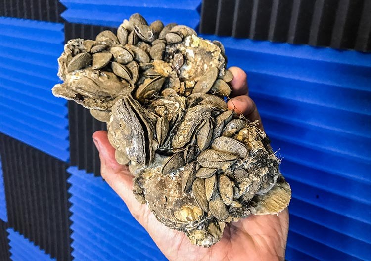
What you see here is a small chunk of a productive oyster reef. If this dies off, the rest of the food chain goes with it.
Do not underestimate the importance of the oyster! Oysters filter the water and stabilize the bottom, making for clearer water, as well as enough relief for bait to hide and grow in.
When an oyster reef dies, the rest of the food chain goes with it. Fish will move on to other places to find food. I'm sure you understand the concept of decreased supply and increased demand.
Spawning Grounds Flooded
Speckled trout and redfish require higher salinity in order to spawn, about 15-17ppt or so. For reference, average strength saltwater is 35ppt.
But when an historically active spawning ground is completely blown out by river water, that salinity drops below the required level and fish aren't able to spawn in that location anymore.
Now, in all fairness, nobody knows exactly where every spawning location for speckled trout and redfish are across Louisiana's coast.
But they still have to go somewhere else. Now, I'm no marine biologist, but it's my understanding that there would be more recruitment across the wider expanse of Louisiana's coast if there are more spawning locations available to inshore species.
What is recruitment?
Recruitment is a ten dollar word describing the number of fish surviving to enter a fishery. That is, the number of fish that survive from being eggs, to larvae, to juveniles, to the point they're eventually big enough to be caught with fishing tackle.
The number of these fish starts out very high with the number of fertilized eggs released during spawning, then decreases as they experience mortality due to a broad range of factors.
In the case of The Freshening, I am assuming that dirty river water was one such contributor.
If you are a marine biologist, and if I am getting this wrong (or right), then please let me know in the comments below. Or, if you'd prefer to not publicly embarrass me, my contact page is always a good option.
Anyway, because there's been fewer places for fish to spawn and grow, we've seen a drastic decline in fish stock, namely for speckled trout and redfish.
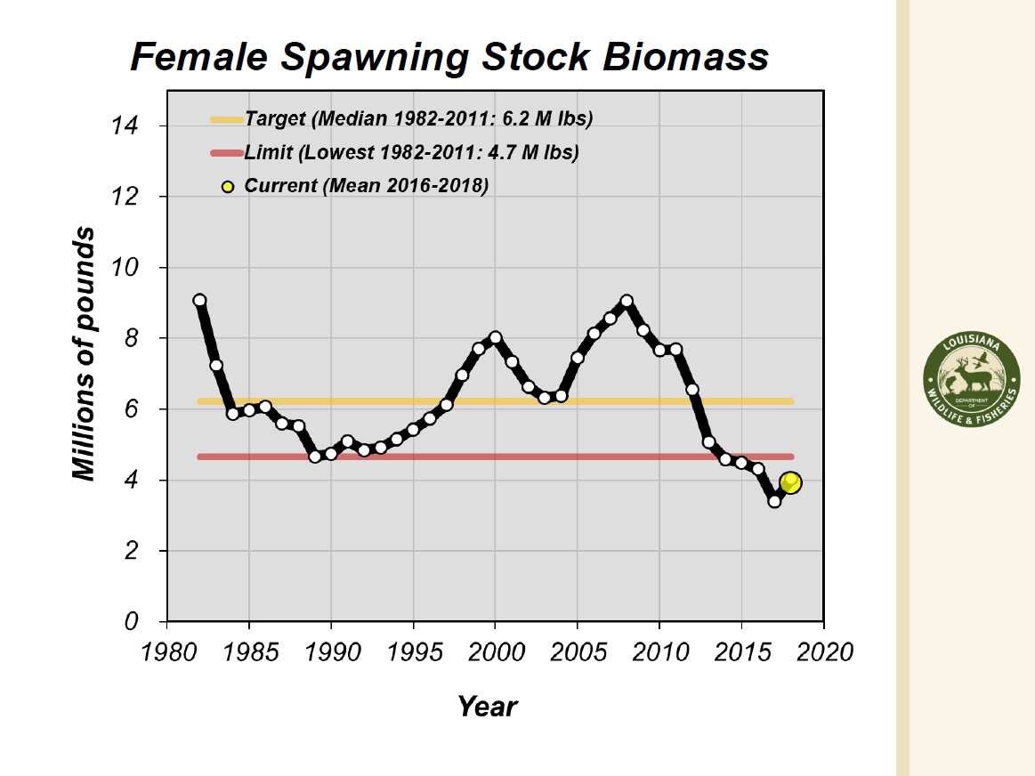
This chart shows the population of spawning female speckled trout. Note how it takes a dump about when The Freshening begins.
That's just for speckled trout! Redfish have taken a hit and other species have become scarce or virtually non-existent since The Freshening began:
These are all fish that we caught routinely in the Lake Pontchartrain Basin before The Freshening changed the area. It has been the same situation in other places that saw lots of river water, too.
Coincidentally, the one area we did not see inshore species seriously decline, especially speckled trout, is the Grand Isle area, from Port Sulphur to Timbalier Island.
This broad area is somewhat equidistant from the Atchafalaya and Mississippi Rivers, so they were not completely blown out by The Freshening.
In fact, I had good fishing trips to that area during this period of time, noting how much easier it was to find and catch speckled trout from scratch than other areas I had been to (that had been affected by The Freshening).
With that said, The Freshening did more than affect the water quality of Louisiana's coast. This phenomena had a more lasting effect, and that's what we look at next:
How did The Freshening Affect The Marsh?
The Freshening of Louisiana's coast did more than alter the fishery through change of water clarity and salinity. It also altered the landscape.
This is important, because the change in fishery can be recovered, but the landscape is something that's more permanent and will affect how our coast fishes going forward in the years ahead.
Now, these things are not necessarily bad, I'm just noting their occurrence, as they can really only happen when the rivers rage high.
New Crevasses Formed
The Mighty Mississippi has created new paths to the coast. What would start as a meandering trickle eventually turned into a large pass, moving many cubic feet of water.
First, there was Mardi Gras Pass, formed on Mardi Gras Day in 2011. This radically changed the salinity in the immediate area there on the east side of the river in Pointe à la Hache.
Before the opening of this pass, people called the area a "paradise" for catching speckled trout! Now, it's far more seasonal and, when the Mighty Mississippi floods, trout are pushed out.
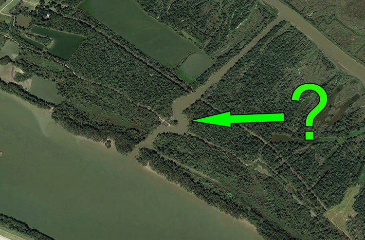
With that said, it's worth noting that the area has become far better suited for largemouth bass and redfish.
In fact, this YouTube video was filmed not too far from Mardi Gras Pass and, if you watch it, you'll see that I had no problem catching a limit of redfish in the most fun way you possibly can: sight fishing.
After Mardi Gras Pass there is Neptune Pass, which was formed about ten years later.
I could go on about it, but Dr. Alexander Kolker has this excellent presentation describing its formation and just how big it is.
My overall point here is that these passes change how water flows and salinity settles out along Louisiana's coast, especially on the east side of the river.
Once The Freshening is over and things return to "normal", these passes will continue to contribute to an overall lasting effect. It's a permanent change worth noting.
New Land Built
Another permanent change worth noting is the creation of new land resultant from the Mississippi River's classic land building quality.
You really only need to pore over Google Earth Desktop to see these features.
The outfall areas of Mardi Gras Pass, West Bay and Neptune Pass are good places to begin looking.
Make no mistake, this is actual land being built! It's not soft marsh mud, it is hard sand!
This "new land" has surprised me more than once in the last seven years, causing me to destroy a lower unit at this location then, years later, completely ground my boat so bad that I needed an airboat to come to the rescue.
Aquatic Grass Grown
Aquatic grasses are not as permanent as land, but they do help shape the fishery in a positive way.
We have had a lot of aquatic grass, mostly a kind of milfoil, grow on Louisiana's coast as a result of The Freshening.
This kind of grass is great for filtering the water and offering habitat for bait to live and grow in.
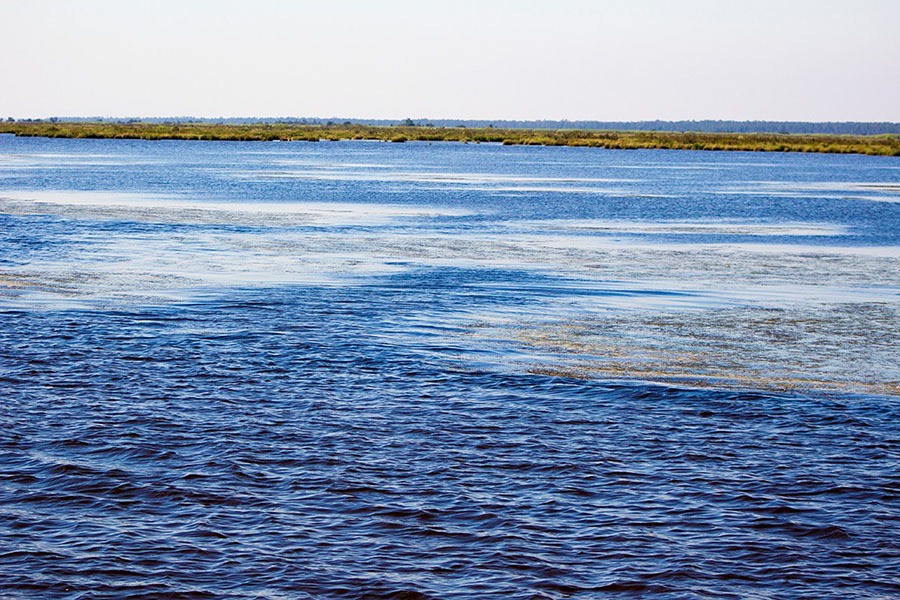
The best fishing I've experienced, whether that be for speckled trout or redfish, has been in areas where there is aquatic grass, with rare exception.
So, what does this all mean for the fishing? Let's explore that next:
Will The Fish Recover? What will happen going forward?
Yes, the fish will recover. At least I think so. Let me explain why:
See, I think the trout and redfish stocks would have taken a beating even if we never fished for them in the first place during the entire Freshening.
Obviously conservation works. Duh. I'm not giving you a license to haphazardly kill everything you come across then be surprised when the fishing sucks.
I do genuinely believe that if we all practiced a little more conservation there would have been more fish to catch all along, but I do have a feeling that the overall reduction in fish stock is contributed to The Freshening and — for the most part — was out of our control.
So, I think that once the fish get their spawning grounds back, once they have more marsh to recruit to, that the fishing will become better.
It could even return to what we used to easily do fifteen years ago!
After that, we got some new land out of the deal. It's not much, but it's better than nothing and maybe it will give our coastal scientists something to study in order to draw better conclusions on how to save Louisiana's disappearing coast.
And, while they do, I hope they also factor in just how devastating too much river water can be for inshore species.
Just remember that cocktail analogy.
Is The Freshening Still Happening?
No, The Freshening ceased in 2021 when we got through the year without a spillway opening and saw the Mississippi River fall to single digits during summer then remain their for the entirety of fall.
This was clinched the following year 2022, with similar results. Here are two charts of the Mississippi River, one from 2019 and another from 2022, just to give you an idea as to what you're looking at:
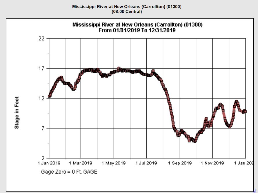
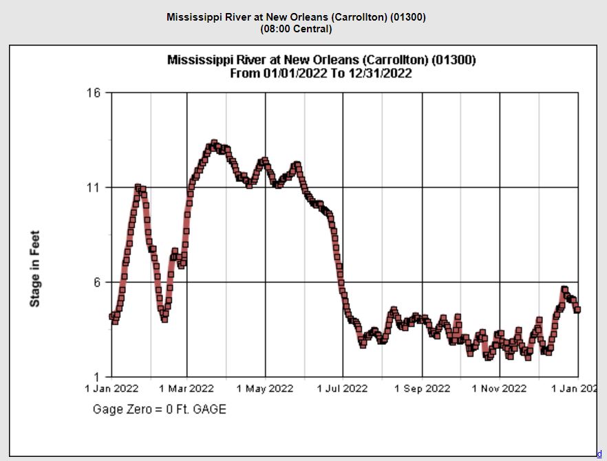
You can see the obvious pattern of "river goes up, river comes down".
I can elaborate on this more, but that is literally a small book and will have to save that for another time. Diving into historical flood data of the Mississippi River is a deep rabbit hole that only the nerdiest of inshore anglers can fall into and crawl out alive.
Trust me. Let's stay out of that rabbit hole.
Anyway, getting back on track:
Here and now in 2023 we are seeing the Mississippi River do the same thing, just at a faster rate: she is getting lower, sooner.
She only got above 13 feet for less than a week before promptly falling. At the time of these keystrokes she is sitting pretty at 3.83 feet. *chef's kiss*
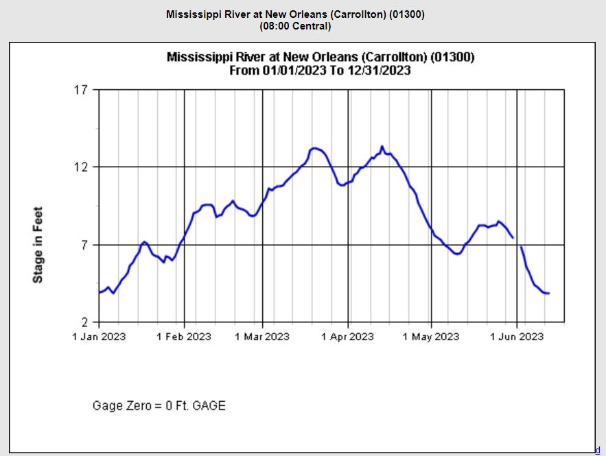
Without falling into the aforementioned rabbit hole (this article is already over two thousand words), I cannot tell you the last time she got into the low single digits in June, or when she got below ten feet in April (as she did this year).
So, this is new! This is earth-shattering! We are seeing the coast change once again and nobody is talking about it!
You read it here first on Louisiana Fishing Blog!
But, if the coast is changing yet again, then what happens next? What can we expect?
The Freshening is over! So, what happens next?
Going back to the cocktail analogy I used earlier: if Louisiana's coast is a cocktail of dirty, fresh, river water mixed with clear, salty, sea water, then from 2011 to 2020 she sure got too much of one ingredient.
This made for a gross drink, metaphorically speaking.
But now that one ingredient has reduced to its desired proportion. And, speaking strictly from an anecdotal point of view, the fishing has gotten better.
Better fishing reports are hitting the pages of social media, especially for speckled trout, but more flounder, channel mullet and spanish mackerel are making an appearance as well.
The fishing is still a shadow of what it was ten years ago, make no mistake! But there's hope.
And I think that we could be entering a new period that I have coined "The Saltening". It is one that we have not had in nearly twenty years!
I've already written about The Saltening in this blog post.
Over To You
What do you think? Have you fished areas affected by The Freshening and, if so, what did you observe?
Do you feel that The Freshening was the chief factor affecting inshore fishing on Louisiana's coast in the last ten years?
Do you believe that Louisiana's fishing can be restored to her former glory?
Whatever you believe, you are welcome to contribute to the completeness of this article by adding your thoughts in the comments section below.

Yeah, I definitely need to read this book.
Yes, I have. It’s quite the terrain model. Absolutely massive.
Thank you, Jerome!
Colin, that’s absolutely true. Thanks for including that.
Also the sediment in the river is lower now than in years past so some of the land building abilities of the river water has diminished.
Great article!
I am pretty sure it was in Beyond Control the issues with the river changing course, like the grain elevators was brought to my attention, as well as the absence of fresh water below Baton Rouge, also the large natural gas pipelines crossing the atchafalaya that would be scoured out. They feed power plants all up and down the east coast. Not to mention all of the smaller oil, chemical and gas pipelines. Environmental disaster.
Have you been the the river display set up on Bator Rouge?
Rising Tide is an excellent book that everyone should read. I have not read Beyond Control, but I will now that you’ve recommended it. I read a lot, and value vetted ideas in books over the superficial shallowness found in social media.
That’s a very good point about the grain elevators. I was not aware of that! That’s why we must look at things practically. Good point, thanks for bringing it up.
As for the fishing, I agree with you, but will beg to differ on the GPS.
Yes, it does help people get about the marsh more easily, no doubt about that. But I think that most people just use it to get to community holes and back to the dock.
I don’t think many of them are venturing out beyond that. I have no evidence for this, just my own anecdotal observations from teaching people how to navigate the marsh.
People are scaredy cats, and mapping chips won’t change that. BUT, to refine your point, I think that a boat and GPS for the *right* kind of angler can be especially impactful on the fish.
Some people are just better at things than others, and are more willing to take risks. Those are the people who benefit from GPS and mapping chips. What would take them years of TOW to figure out an area they can do in a much shorter amount of time.
But, I think those people can be converted to think more conservationally, and can be made into allies for conservation, releasing more than they catch.
I’ve seen this and that has been my own experience as well, and is part of what I do with LAFB.
Anyway, thank you for your thoughts, they were most insightful.
Great article, there are so many variables. I am about to go all over the place here.
I remember the days of no limits as a kid. I know people say fishing pressure isn’t affecting it but I believe it does. Before GPSs if you didn’t know the water or couldn’t read a map you didn’t buy a boat, now everyone can safely navigate with the help of electronics and maps like LA1. I think charter fishing/bowhunting should be more regulated like the commercial fishing it truly is. I have heard the arguments about what goes on offshore and how the recreational snapper fishermen get screwed, but there are so many recreational inshore fishermen that the politicians would have to think twice about giving the charters prefferential treatment inshore, but that’s another story.
My dad worked for the Corps of Engineers and was raised on Bayou Lafourche so I got a lot of history first hand. The book Rising Tide by Barry was one he always pushed us to read. Another good one is Beyond Control by Barnett. The river changing course would have devastating affects locally, across the US and world wide. All of the grain elevators are between Old River and the mouth, so all of the grains shipped overseas would have to be rerouted.
I have also noted how much more trees were growing on shorelines in the areas fed by the Davis pond diversion. The fresh water has definitely brought that area back to life.
Thanks again for the article.
Yeah, that’s great research. Thanks, Jerry.
Hey Bruce, thanks for reading!
I agree, thanks for reading!
Captain Devin, I live in Vicksburg, MS but have been an avid coastal fisherman for the last 20+ years. In my observations over time, these “freshening” events are cyclical in nature. As you make note of, the last 2 years and continuing into this year the river levels have dropped much earlier and remained relatively low during that June-December period. I had great success catching trout the last 2 fall seasons in areas close in that had not produced much in almost 10 years. Just as the freshening took place over the span of 8-10 years of high river cycles, I am hopeful that the “saltening” will cover an equal span of time and that we can get the 2 big pluses of (1) an improved fishery, and (2) some of that newly created land can convert to productive marsh. Thank you for your inciteful article.
Great article. I agree with what you said. Just think of how much land was built before the levees were built. The fish will be somewhere around our state, but will find the best habitat for them. I’m not sure the land is sinking but it is subsiding or being washed away. Keep up the good work. I look forward to seeing your next article.
You are right in my head, brother. I used to catch more bass than flounder. Now since they haven’t opened the spillway, I catch a lot of flounder and no bass. Same techniques, same areas. Fishing has been “off the hook” the past year! And seems to get better. The water has been unusually awesome, but a different approach is needed now the water is so clean. I find I gotta ‘neak up on em with finesse. Almost like romance them onto my hook. Hoo ya! Geaux Navy!
Found this in a quick search …. Part of the puzzle from that period
“Although the commercial catch had been regulated by minimum sizes and gear restrictions, the recreational fishery was unregulated until 1977, when a combined daily limit of 50 was placed on speckled trout and redfish. In 1984 the possession limit was reduced to the daily limit, and a new saltwater fishing license was required. This was followed by a 12-inch minimum size (14- inch commercial) in 1987 and the recreational limit was reduced to 25 in 1988.”
Let it get back to what it was and Louisiana will be crushing the competition on Release Over 20. It won’t even be close. We will hilariously lead all the other states by hundreds of fish. Of course, the effort that you, Cliff Hall and others is very key in that. Getting people off the ziplock mentality is a key first!
100%agree. Louisiana and I love it had better wake up and face reality
Although Conservation has to begin with me
Thanks Wayne!
Hey Bill, good question.
That’s kind of an apples and oranges approach.
That’s because those diversions won’t be pumping out river water at the same rate as The Freshening.
The missing context in your statement is the amount of river water to begin with.
People complain about diversions that don’t exist, and point to the last ten years as an example.
But the last ten years wasn’t resultant of diversions (because they don’t exist). It was resultant of an asinine and unproportioned amount of river water descending upon a coast not used to that much.
The issue wasn’t diversions. It was *gravity* and a *lot of rain*>
So, if you can figure out how to solve for gravity and rain, then you would have answered your question. But I doubt you’ll ever get gravity to stop pulling down, or keep snow from melting. If you do, DARPA and JPL would love to know. lol
But, to your point, YES, diversions will change an area and how it fishes. And if it’s anything like Delacroix and Venice, then it’ll probably be awesome.
The difference is that the river has to go down. If it doesn’t go down (like what happened in the last ten years) then it won’t matter if there’s a diversion or not, because it will screw up the entire coast.
Otherwise, you could have a diversion ten miles wide and it won’t matter when the river goes down because (you may have noticed) even the river greens up when she’s not ripping at 17 feet.
The point here isn’t diversions. The point here are river levels on a geological blink of an eye.
After that, a relatively few amount of oyster leases directly in the path of diversions probably aren’t going to do so well. I hate that, but the state is sinking and something needs to be done and that’s the best plan the folks at CPRA have as of now.
I recommend getting involved and talking to your state rep about it.
Those are good questions. I’m not sure what the impact in the 80s was without doing any research, assuming those numbers from then are accurate (like you mentioned).
Sorry I don’t have a better answer for you.
In the Female Spawning Stock Biomass chart, provided the numbers are reasonably representative of the actual biomass across the decades shown, the stock seems to have crashed in the early 80s and continued to decline until the early 90s, then, with some fluctuations, grew at a rather impressive rate until the “recent” decline attributed to The Freshening. It was the early 90s when I started fishing LA, and it was a paradise (and despite the ups and down, I still consider it a paradise). What transpired in the early 80s, and what changed to spark the growth that started in the early 90s? Were there changes to offtake (commercial offtake perhaps), or was this another environmental episode that had a similar impact to what’s being described in this article?
So the bigger question is how are the planned diversions in Barataria bay and Breton sound going to affect salt water fishing. The Impact statement filed gives a pretty grim view for oysters, shrimp and trout fishing. The Freshening as you put it will be an every year thing.
Very informative article I enjoyed reading this and agree with you 100% thanks for sharing this
I started my inshore fishing journey in 2020, so I haven’t experienced what the fishing was like beyond 3 years ago.
That being said, after reading this article I am hopeful to see the fishing get better in years to come!
Hey David, thanks for reading.
I’m not sure how many more people are on the water, but it could be worth checking license sales to verify that number.
James, I agree. I’d rather have bigger fish to catch. I hope that our fishery recovers to what it once was.
I agree! Fish are better off being caught than being eaten and never caught again. Thanks for reading!
Hey Frank, thanks for reading.
No, I didn’t mention the closure of the MRGO because I don’t think leaving it opened would have made a difference in the amount of river water arriving to Louisiana’s coast.
In fact, having it closed probably helped our fishery.
It definitely affects salinity over the long term, but even if it were open from 2011-2020 we just would have seen a bunch of river water travelling up it. A bunch of dirty river water that doesn’t allow aquatic grass to grow.
So, the area where fish were going during The Freshening, because it’s protected from dirty water, would have become unviable.
Remember what areas inside the MRGO have been historically productive during the entire Freshening. I think those areas would have turned off if the Rock Dam wasn’t there to protect them.
I believe that another issue that I have not heard talked about is Covid. Meaning, that for nearly 3 years now, tons and tons of people have had their lives altered by the pandemic. And this altering has made that tons of people have either the ability or the TIME to go fishing. I don’t have any data, just my experience at the boat ramp (unusually crowed) and out in the actual marsh. There were many, many days that I would fish and never see another boat. Just the opposite in the last 3 years. There is never a day that I go fishing that I don’t see plenty of boats. Just my thoughts.
Thanks for reading!
I think the point I was trying to make is that the fishery could recover without our aid and that we got so much river water it wouldn’t have mattered what we did.
The point is the amount of river water. If it’s not a lot, then opening a diversion really won’t matter. You do realize that the Lake Pontchartrain Basin is flooded annually anyway, right?
Great article! The “Freshening” has definitely had a negative impact on the fisheries in the Mississippi Sound, Lake Borne and the eastern LA marsh. LA should consider increasing trout size and lowering creel limits and also adjusting the redfish restrictions in order for these species to fully recover. And, find another means of diverting the MS River that doesn’t destroy the Mississippi Sound and surrounding areas like it did when the spillway was opened multiple times in two years.
Absolutely excellent article. One omission I did see was the closing of the MRGO. Essentially that shutdown a massive saltwater pipeline which only added to the freshening of the entire Pontchartrain basin south. I fish both sides of the river and have had great success catching on the west side in the last few years because it is saltier. I now carry a salinity meter everywhere I go. Once the mid Barataria diversion begins the Barataria basin will definitely change. It’ll be interesting to see. I’m not 100% against the idea of a diversion but id prefer to see it farther south. No matter what someone would be unhappy with its effects. If we don’t see some more land built in that area the entire west side of the river will be water front up to the levee in the event of a bad hurricane. Practically happened in Ida.
Excellent article. But dont let this overshadow the need for better management. The regulations on redfish have not changed in over 30 years. There are way more people out fishing and its gone up a lot in the last several years. The redfish bag limit and/or slot size needs to be changed. Nobody needs to go out and kill 5 redfish and the killing of even a single bull (breeding stock) is just plain dumb.
Yes, we had the same thing going on in our Mobile Bay system. The Trout fishing really started to improve last year and is better this year, but like you said…it still no where near as good as it was 10 years. There was also a few years of a really cool spring, coupled with a high Mobile River gauge. I felt that the Trout spawn really didn’t get going until mid-late May, a full month late. The increased fishing pressure has something to do with it too. There is just so many more boats on the water. Alabama went from 14”min, and 10 trout, to a 15” min and six, with a slot. There was overwhelming support for the change; everyone agreed, something needed to be done. I don’t understand how anyone would want to clean a cooler full of 12” Trout.