Hydrocoast is a fantastic mapping tool for inshore anglers wanting to catch speckled trout. Here's everything you need to know plus a tutorial on how to use it.
More...
Understanding Hydrocoast Maps To Locate Speckled Trout
It is absolutely mind boggling to me the amount of information available to inshore anglers these days.
Here's a few:
These simply didn't exist "back in the day" and, if utilized, will get you a step ahead of other anglers by jump starting your learning curve.

"Don't mind me, just getting ready to go fishing."
Now there's another great resource to add to that list: Hydrocoast!
Not sure what that is? Keep reading to get the 411 on this excellent mapping tool.
What is Hydrocoast?
It's a special kind of mapping product that reflects various environmental conditions across Louisiana's two most prominent basins: Pontchartrain and Barataria.
Specifically, there are five maps published on a bi-weekly schedule:
These maps are published by the Pontchartrain Conservancy (or PC) and are created for public use, whether it be a government agency in some high wizard's tower or guys like me and you who just want to catch some fish.
Where are Hydrocoast maps found?
You can find them on PC's website at this link.
How are these maps useful to inshore anglers?
Well, not all of them are.
The most important map for us inshore anglers is the salinity map.
All the others fall in the category of "fun to look at but not practical".
Knock yourself out if you love nerding out on that kind of thing, otherwise let's keep it simple with the salinity map and how you can use it to plan your fishing trips.
Speaking of fishing trip planning...
Hydrocoast is practically a centerpiece for fishing trip planning during the summer months, so you should take my seasonal courses inside LAFB Elite to get an idea as how to guesstimate where biting speckled trout will be.
Interpreting Hydrocoast's Salinity Map To Locate Summertime Specks
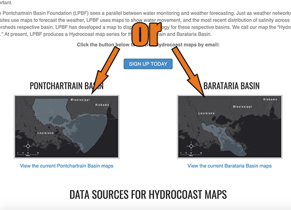
When you first visit Hydrocoast's website you will see that they have options for either basin.
Pick the one that applies to you and open the salinity map.
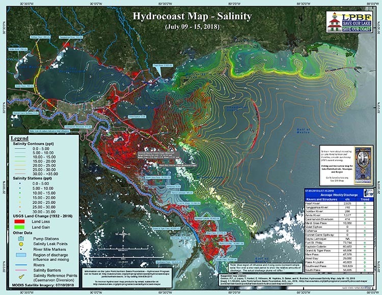
On it you will see a bunch of info boxes, icons and squiggly lines everywhere, as if it were a topograhic map.
Well, it's not. Those lines represent the level of salinity in the water.
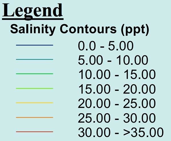
The only info box you really need to be paying attention to is the salinity legend.
This legend describes the blue lines as being freshwater (0 - 0.5ppt), and red lines being average-strength seawater (35ppt).
We know that specked trout need roughly 15 - 17ppt in order to spawn, right?
Anything less and their eggs will sink to the bottom only to be smothered.
Well, this map does a fantastic job of eliminating a lot of unproductive water, giving you a good idea where to begin looking for speckled trout.
It's really that simple.
Hydrocoast's Salinity Map Doubles As A Learning Tool
Now that you understand this, take another look at the Hydrocoast map and it's obvious that a lot of Louisiana's coast is not as salty as you think!

Middle-aged man from Kenner coming to grips with the fact that salinity is not the most important factor to successful inshore fishing (2019 colorized)
It's true, we catch speckled trout in low salinity water and redfish live just fine in landlocked freshwater lakes.
In the future, when you catch fish in the Pontchartrain or Barataria basins, pull up Hydrocoast and see what the salinity level is for that area.
Real World Examples
Here are a few fishing trips (that caught a limit of speckled trout) and the salinity level according to the Hydrocoast map for that period of time.
- Chalmette 9/15/18 - 4ppt
- Rigolets 10/1/18 - 2ppt
- Geoghagen 1/15/19 - 0.5 - 3ppt
Those salinity levels are pretty darned low, which may have you thinking, "How reliable is Hydrocoast?"
From experience, I would say it's fairly accurate.
A good way to know is to watch the salinity gauges for each map's respective basin and compare that against what's depicted on the map.
In fact, here are two from August 19th-25th, 2019 : Bay Gardene and Rigolets.
Rigolets Salinity Comparison
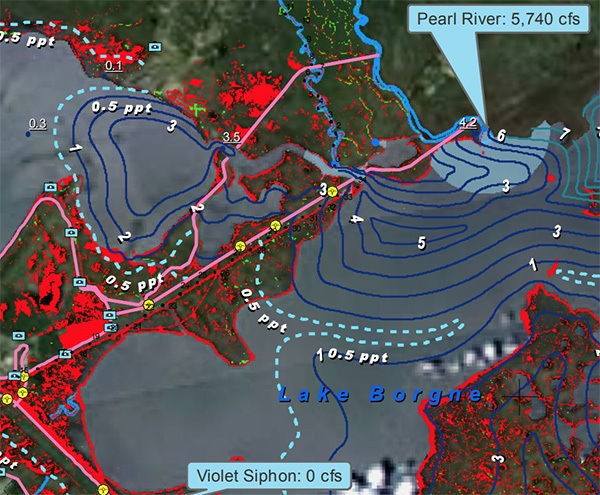
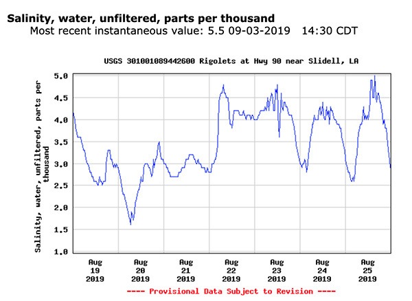
Rigolets Salinity Comparison
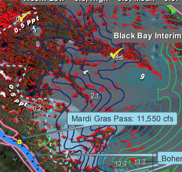
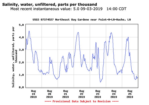
You can see that Hydrocoast is pretty spot on, and it's a safe assumption that it is a reliable tool.
In addition to this, we've measured salinity and found it matched with Hydrocoast.
Follow this link for a full breakdown of how they create their maps.
Other Learning Points & Things To Think About
What new forage does all this freshwater bring to the table?
Do speckled trout take breaks from spawning and push into lower salinities to take advantage of new feeding opportunities?
What other species are saline-dependent and could be targeted with such a map?
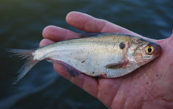
More and more gizzard shad have arrived with "The Freshening" of Louisiana's coast. How do speckled trout and redfish respond?
These are things to consider, because forage like gizzard shad does not behave the same as pogies (gulf menhaden), possibly influencing the behavior of speckled trout and redfish.
It's safe to say that time will tell.
Comment below to share what you think.

I just saw that! That’s a bummer!
Website states funding for barataria basin maps ended in Dec 2019. Click on barataria basin maps.