You already know how my lower unit was ripped in half. In this video I detail how it could’ve been identified and prevented. I show you step-by-step.
The last blog post detailed the story of how I lost my lower unit in Venice, Louisiana.
Here, in this one, you'll see exactly how the unfortunate incident could've been avoided in the first place by going through these steps:
How West Bay Has Changed
The only constant in Louisiana is change.
River water, hurricanes, dredging, levees - all these things have changed Louisiana's vast landscape.
Not sure? Just look at these screenshots from Google Earth.
West Bay in 1998
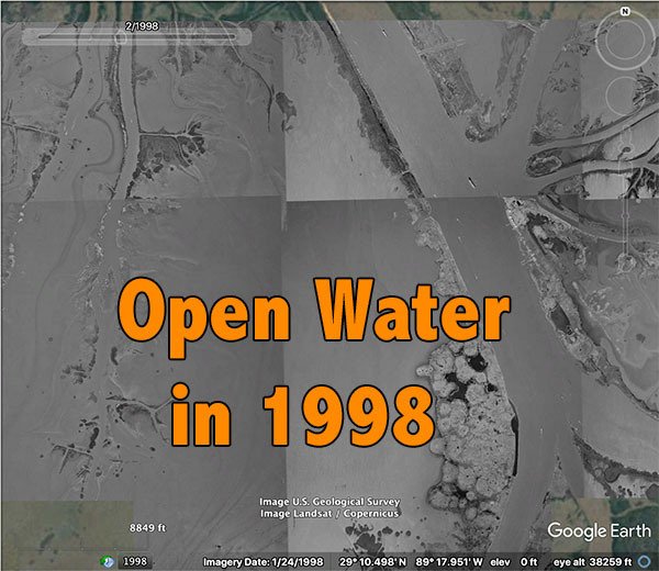
The water in West Bay, according to Earl Armstrong, used to be six to seven feet deep across.
That's a far cry from what's there today.
West Bay in 2016
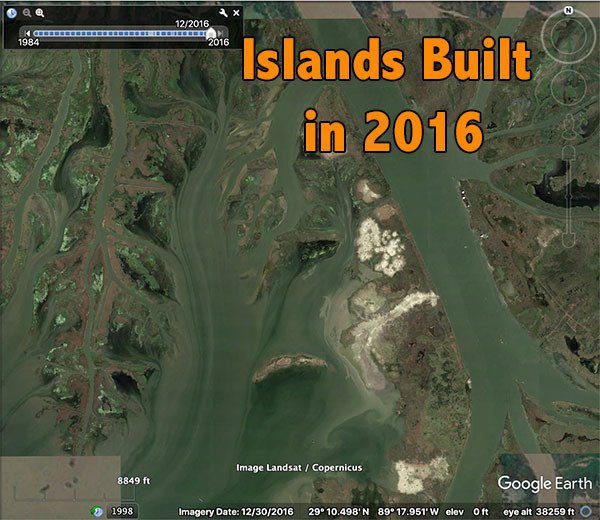
As you can see, there are islands, not flottant, but actual land you can walk on.
Not sure? Watch the video below detailing this change, then come back and finish up this blog post.
Tracing My Steps
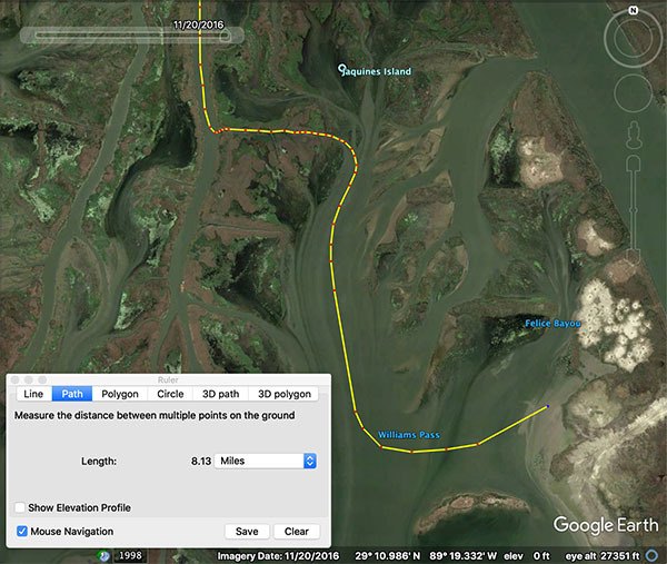
Here's the route I took from Jaquine's Island, down through West Bay, across former Felice Bayou and into the canal of death.
NOTE: This is not a track pulled off the boat's GPS, it's one I made from memory, so it's not exact, but it serves its purpose of showing you where we went.
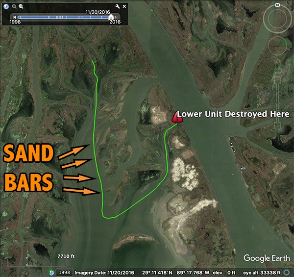
The Canal
Take a look at this screenshot of the canal we ended up.
Looks like any other canal in Louisiana, doesn't it?
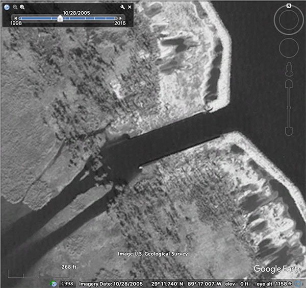
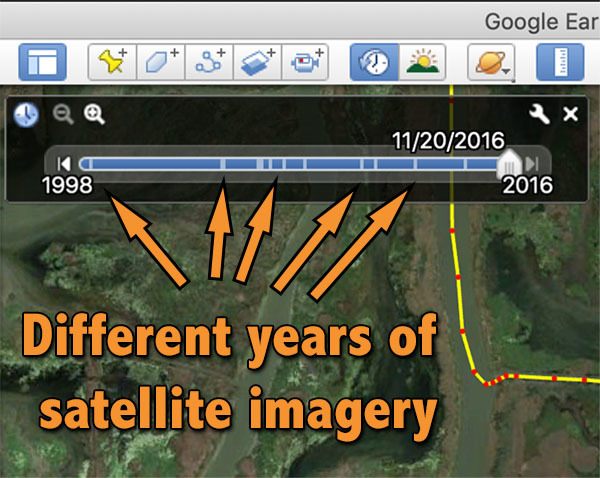
Upon closer inspection with Google Earth's Time Slider, it's apparent that something isn't right.
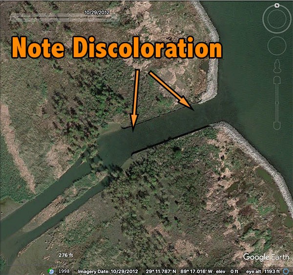
The discoloration does look like submerged aquatic grass, but then that would indicate the canal is much shallower than water on either side of it.
That doesn't make sense, since canals are dug to facilitate boat traffic.
This calls for more review using satellite imagery taken at another time, hopefully revealing some detail to explain what's different about this canal.
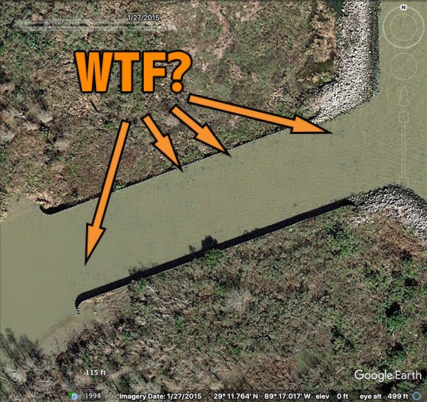
The timestamp for the above image is 1/27/2015, and here we see muddier river water characteristic of the higher levels experienced during that time of year.
And it's apparent that something is amiss. What are those black dots?
Something isn't right...
If I never had my accident, possessing zero knowledge of this canal, and conducted this research, it's likely I would have avoided running the canal or at least idle to inspect what's under the surface.
Maybe I would've seen the riprap on the shoreline of the Mississippi River and assumed the discoloration was produced by shallow rocks.
We'll never know for sure, but I definitely would've prevented this accident from happening if I had done this kind of route research.
What the hell is this canal?!
If this canal is laden with rocks and made to be shallow, then why is it there in the first place?
Well, it turns out the canals (yes, there's more than one) were dug in the 1980's by the U.S. Army Corps of Engineers to prevent uncontrolled overbank flow.
Since they were designed to only pass river water, and not sediment, rocks and sheet metal were installed in the canal and nearby shoreline to prevent scouring and subsequent enlargement.
This eliminated the need for future maintenance.
Why isn't this canal marked?
Ha ha ha! Don't be naive.

Anyways, if you want to see the exact coordinates for these canals, either watch the video above or visit this blog post.
Creating a Route That Safely Avoids These Underwater Hazards
The video above does a pretty good job of detailing how you can do this, but I'll break it down here, too.
Just understand that you are 100% responsible for your fishing trips!
Determine The Destination
Let's say we want to go fishing on the eastern shoreline of West Bay (Point B), and need a route that will safely get us there and back, starting from Grand Pass (Point A).
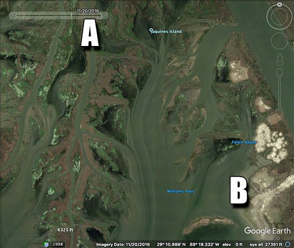
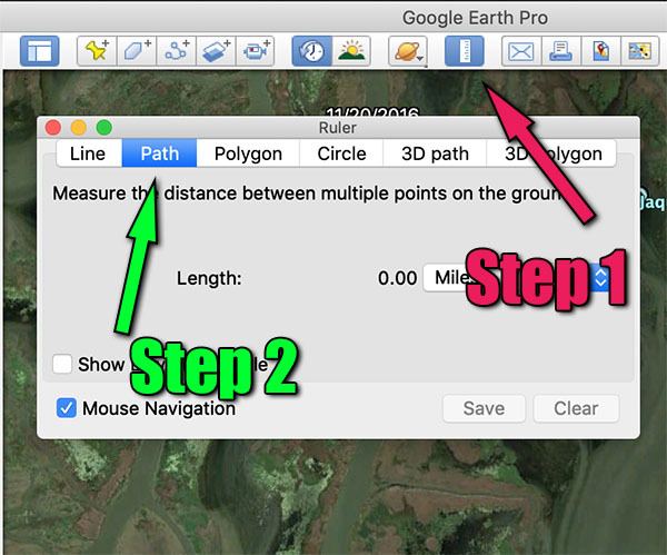
Select the Path Tool
Next, select the ruler icon (Step 1), then select the Path Tool (Step 2).
Create the Route
Now, go ahead and create the route you want to take from Point A to Point B.
As you do, flip back and forth on the Time Slider to inspect your route, steering clear of hazards and obstructions, such as sandbars, etc.
And You're Done
All you have to do now is save the route and upload it to your boat's GPS for use on the water!
Remember This Very Important Detail
It's not a matter of if but when.
You will hit an underwater obstruction. You will run aground. You will get stuck.
The odds are against you, and the more you fish the more susceptible you become.
No, it doesn't matter what preparations you made, what kind of boat you're running or how badass you think you are.
Why? Because shit happens.
It is your responsibility to ensure your fishing trips are safely conducted and that you and your buddies return home on time and unharmed.
What this blog post provides is just a lesson, one you don't have to learn the hard way, and a tool to help you.
Want to learn more?
If you enjoyed this blog post and want to learn more inshore knowledge (the easy way), then you should consider signing up for LAFB Elite.
Once you're a member, you'd be joining other inshore anglers and gain access to all of my courses and the LAFB Elite Community.
There is no better way to boost your inshore fishing game!

Thanks, Barry. This video was recorded in 2017.
I noticed that the Google Earth you were using is an older version. FYI The newer version includes a data settings port so one can change the format of info given. Newer version has a blue globe at the right hand side of the tool bar. I use it for conversions of coordinates to match my GPS. Just throwing it out there. Good video
Thanks for commenting!
Electronics are good, but the planning described in this article is better, at least for detecting something like this rock pile.
Actually, you somewhat described Navionics Sonar Chart, which doesn’t really apply to what we do, but works well enough for inland bodies of water, like reservoirs.
Tight lines
I fish more water than ever before now with the comforts of electronics, but I swear I pucker up every time I’m running in virgin water. I tend to plane off and throttle back and lift jack plate up. I’m envisioning 30 years in the future you’l be able to subscribe to a safe routes service that all boaters upload safe routes and hidden hard obstructions and low water.
30 years back I’m sure some guy was wanting 3D sonar and GPS.
That could have been me in October. Was fishing near there and considered going through but changed direction to fish a different area. Whew!