The white PVC pole is the most common marker you will see anywhere inside Louisiana’s inshore waters. These things are everywhere and they all serve different purposes, some of which even contradict each other.
For example, a white pole can mark an underwater hazard, something you don’t want to hit, or it can mark a channel you want to keep your boat in.
If you confused one for the other you can end up in an accident rather quick. It’s maddening, isn’t it?
So how do you know what is what? I'm writing this article to detail exactly that, so let's jump into this:
White PVC Poles Mark Two Different Things In The Marsh
We begin learning what white poles are used to commonly mark by breaking them down into two categories:
White Poles for Navigation
Often we see white PVC poles used to help people get about the marsh.
In some areas that are shallow, white poles are used to mark the channel for boats to stay in, especially during periods of low water. These white poles are lined up in a row.
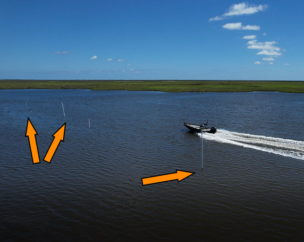
Brady Lagoon can get shallow, and these white poles mark how to get through on low-water days.
Sometimes single, larger white PVC poles are used to mark a point. This really helps in identifying that point in order to make the correct turns when navigating through the marsh. Everything out there looks the same, so it can be hard to know where to turn, especially during periods of low visibility.
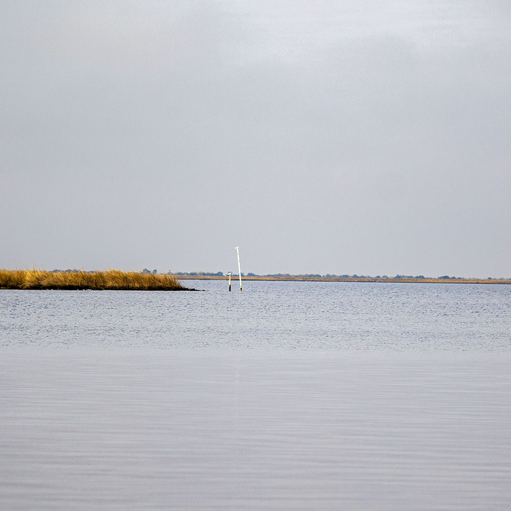
Sometimes you see a single, large white pole used to mark a point or significant turn in the marsh.
This is less of a concern now that we have advanced GPS technology, but back in the day having those white PVC poles on the point was a huge help.
In many ways it still is! They still help when during hours of before morning night twilight.
White Poles for Underwater Objects
You’ll see white poles used to mark various objects underwater, and those objects may or may not present a navigational danger. Let’s go over each one:
Oyster Leases
Where we see white poles used the most is to mark oyster leases. These leases can be larger than a football field, or the size of a modest driveway.
Sometimes the white poles are placed down the middle of the lease to mark where oyster cultch was dropped, other times they are placed on the edge of the lease to mark its boundary. It just depends.
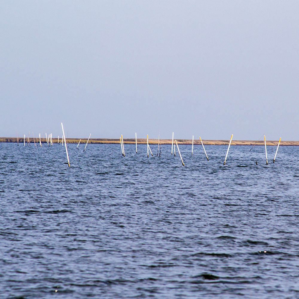
At water level these white poles appear to be randomly placed, but they're almost always outlining the boundaries of an oyster lease.
There are so many of these in the marsh that they can be spotted in the clearest imagery on Google Earth Desktop. For example, check out the below screenshot from the Biloxi Marsh. On the right you can see a major point and — on the left where the orange arrow is pointing — is the row of white PVC poles used to mark the boundary of the oyster lease.
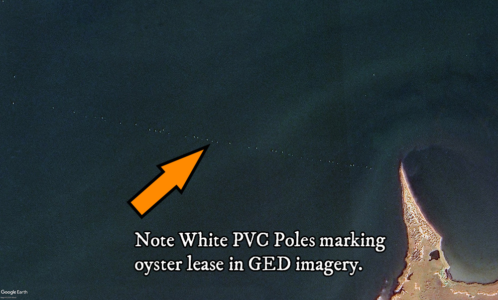
You can use satellite imagery to locate long strings of white PVC poles in order to locate the best areas to run for triple tail. Not familiar with this floaty fish? Learn more in my primer here.
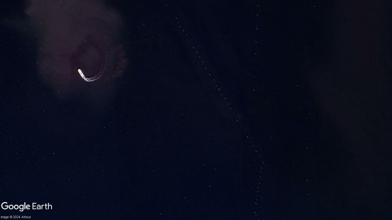
This oyster lease in Empire is filled with so many white PVC poles that you can literally see it from space. Note the oyster boat dredging in upper left corner.
Underwater Hazards
Things that are very nasty for your lower unit may be marked by a single white pole or a series of them.
It’s not uncommon to see a single white pole marking an old wellhead that’s underwater and no longer visible, or marking a pile of rocks just under the surface, like the one that got me in Venice.
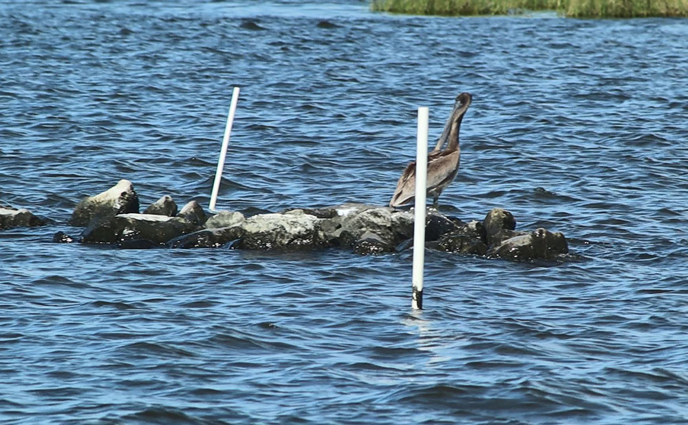
These rocks are barely visible when the water is low. When it comes back up, they'll be easy to overlook and lose a lower unit on.
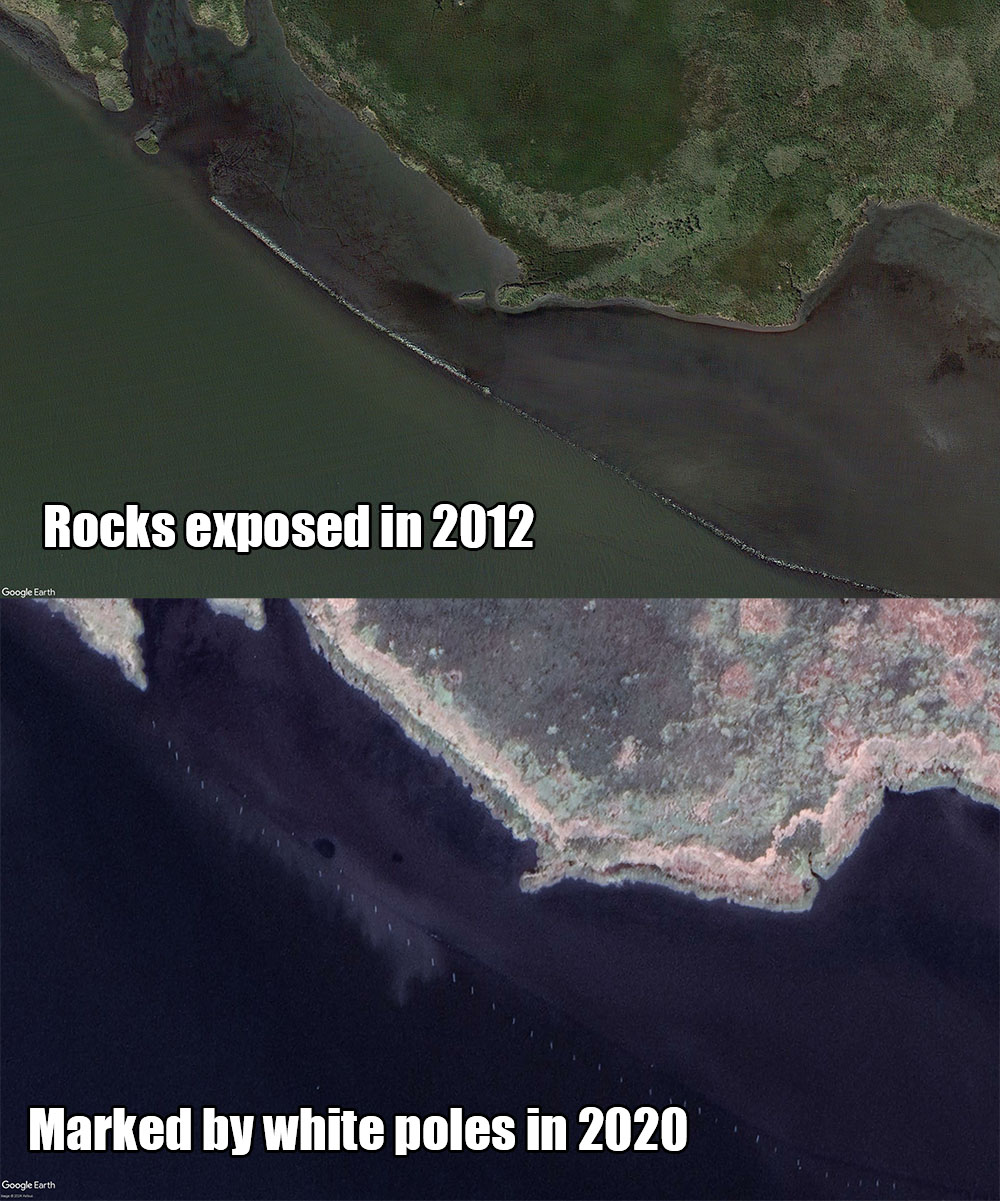
Sometimes long rock piles used to reinforce a shoreline will gradually sink beneath the water, like this example in Shell Beach, and long white PVC poles are used to mark its location.
It’s also the case that a row of white poles may be used to mark an oilfield pipeline. Sometimes these are deep enough to not be a hazard, other times not so much. If anything, they are marked to prevent people from anchoring or dredging on top of them.
So how in the hell can you tell the difference between the safe and unsafe white PVC poles?!
Your head may be spinning by now and, quite frankly, I don’t blame you. It’s absolutely maddening that anyone would use the same system of marking to identify completely different things that are either helpful or harmful for your fishing trip!
It makes you want to pull your hair out and scream!
How do you tell the difference between a row of white poles used to mark an oyster lease or a dangerous rock pile? As you can see in the pictures above, they practically look the same!
The Answer: It's all in the details, or the context of where the white PVC poles are located...
Let’s take another look at the example of this sunken rock pile in Shell Beach. If you'd like to follow along, you can find them at these coordinates:
29°51'54.58"N 89°41'55.12"W
I would look at the white poles marking it and think “that is not an oyster lease”.
That's because oyster leases tend to be in open water and not against a shoreline. Oysters are filter feeders and putting them near the shoreline takes them out of the tidal highway where there’s less food.
Additionally, putting an oyster lease near the shore risks exposing them to cold air during the winter.
It just doesn’t seem like a good recipe for growing oysters. That and I can look at the LDWF Oyster Lease Map and see that there is no lease for that location.
So, whether I first encountered them on satellite imagery or in person, I would look at that row of white poles and think “that’s marking something screwy”, especially seeing that there are, in the vicinity, other rock piles clearly visible above water along the shoreline.
Now, I wouldn’t look at that row of white PVC poles and think it’s marking a channel, either. That’s because this body of water is the MRGO and the channel is very clearly in the middle of the 40ft deep canal that was dug decades ago.
This seems obvious, but if you’re not from this area it’s not obvious at all. This is why I like reading the history of places, in order to learn more about them and discover technical specifications like the project depth for the MRGO. I doubt 40ft of water has silted in that much during that amount of time.
I would not look at that row of white poles and think it’s a channel, I would think something screwy is going on there.
And, after looking at it on Google Earth Desktop, it’d be obvious that it’s a long rock pile that, at times, is submerged underwater.
This Highlights Why Google Earth Desktop Is The Best
With Google Earth Desktop (or "GED" for short), you can flip back and forth through the time slider to analyze historical satellite imagery and arrive at a better conclusion as to what's out there in the marsh waiting for you.
Or you can wing it and learn the hard way (i.e. hitting underwater rocks with your boat).
You have to use a little deduction and reasoning here. At the end of the day you can’t go wrong with going slow and taking a careful look at things in order to establish a proven and reliable safe route.
I know that if I were crossing an open body of water, like a lagoon or bay, and there was a random, single white PVC pole in the middle of it, I would give it a wide berth. It’s probably marking something bad for my lower unit!
Oh, and sometimes canes are used in place of white poles. It varies, but white poles are more dominant.
So, that’s white PVC poles and their insane multi-role function for navigating the marsh. It’d be perfectly reasonable to assume there could not be anything more confusing or exasperating intentionally deployed in the marsh, but I hope that this guide gave you better clarification so you can enjoy safely fishing the marsh. :)
Learn More About The Marsh & Where To Catch Fish
If you'd like to learn more about safely navigating the marsh and find your own fish to catch, then I strongly suggest taking my course Inshore Fishing 101.
This course is not for beginners! No, it's the foundational knowledge of inshore fishing that everything else builds upon. It is available only in LAFB Elite, my membership granting access to all of my courses and community.
Jeffrey Stewart
Inshore Fishing 101 transformed my fishing trips!
I grew up fishing Delacroix with my dad from age 8-14. I never understood what we were doing or why, and didn’t think to ask questions. Dad did all the leg work and put us on the fish, I just threw at 'em and reeled 'em in.
Today, Captain Devin's Inshore Fishing 101 helped me learn all the things my dad knew to make those fishing trips happen. I'm able to plan good fishing trips to find 'em and catch 'em.
This is much easier due to Devin's ability to "dumb things down" and make fishing concepts easily understandable.
Now 18 years later we are getting a new boat and getting back on the water. Looking forward to showing Dad what I have learned!
Barry Magee
LAFB Elite is well worth it!
Jerry LaRocca
More Rounded Angler
I just want to say job well done, Devin!! I think anyone who completes the course will be a more rounded angler, with more ammo in the magazine, so to speak. New angles to think about and apply to their fishing game.
I know I learned a lot, have applied it and have seen the difference that more knowledge produces! Thank you, Devin!!
Are you already a member of LAFB Elite?
Then let me show you what you need to do!
First off, I strongly suggest completing Inshore Fishing 101 if you have not done so already. It's very important that you complete that course from beginning to end so you have all the context.
Second, the part of 101 that's related to this guide is the Advanced Inshore Navigation section. You will be asked to login upon clicking that link if you are not already.
Last, but not least, use the LAFB Elite Community to get feedback on safe routes and where to go fishing when planning your fishing trip. Chances are another member has already been to the area you want to fish and can provide feedback on navigational hazards to watch out for, whether they are marked by white PVC poles or not. :)
What do you think? Comment below!
What's your experience with white PVC poles in Louisiana? Is there something I missed?
Either way, I enjoy it when people take time to visit my site, and I know a lot of experienced inshore anglers do. So, if you have something to add to the value of this guide, then please do so in the comments section below
Thanks for visiting, and tight lines!
